Paper presented at the TAG 2010 Conference at Brown University

The use of particular types of sacred places in different religious practices is often the means by which belief systems are analyzed and distinguished from each other. For this and other reasons, ancient and modern beliefs variously described as shamanistic or animistic, but better understood as ancestor and spirit worship, are presented as inherently different from organized or “high” religions. This spurious distinction is enabled by (among other factors) a dichotomous analysis of the place where the sacred is enacted: Is it a cultural or a natural landscape? Built or wild?
The implications are obvious. Belief systems that are seen as less structured, such as ancestor and spirit worship, are presented as natural or spontaneous practices centered on individual spirituality, mobility and, most importantly, the natural landscape as the privileged ritual setting. To the contrary, organized religions, like Buddhism, Christianity, or Islam, are seen as urban practices that inhabit the constructed or domesticated landscape and are bound by clergy, defined rituals and fixed (constructed) places of worship. As a consequence, places of worship of organized religion are carefully distinguished from those locations where participants in loosely structured beliefs systems enact their rituals, even though both may occupy the same area, contiguous locations or structurally similar spaces. Geographers and philosophers have discussed at length the issue of place and space, trying to disentangle the presumed differences that distinguish the two. In general, most researchers, such as Tuan (1977), see space as more open and less specific than place; though some have problematized this distinction (Casey 1996). I would like to move beyond this and other dichotomies and focus on a more unifying term, such as landscape, because I prefer to highlight similarities rather than differences. Nonetheless, I want to clarify that, opposite of Tuan (1977), I interpret space archaeologically, that is as a physically confined or enclosed place.
In China, these distinctions are perhaps even more pronounced, as the size of the country and its ethnic and cultural variety invite many separations and classifications of beliefs and places. Differences are assumed about the nature of a sacred place based on its position in the territory, its stylistic or structural qualities, as well as the ethnic and cultural affiliation of the local inhabitants.
Notwithstanding the creation of these artificial separations, it is clear that, aside from cultural peculiarities, there is little difference in the ways the various religions identify, obtain and use sacred places. Landscape and movement have consistently played a major role in all belief systems, no matter the complexity of their organization. Indeed, if the place of landscape in worship is prominent in cultures where mobility is a mode of life (hunter-gatherers, pastoralists, merchants, travelers), the sacrality of particular places and the necessity for believers to go on spiritual journeys to reach them is likewise a constant in the organized religions of settled cultures. Thus, Buddhist, Muslim and Christian believers are often expected or even required to participate in ritualized movement to sacred places or on ritual routes to fulfill their religious duties or to acquire a deeper understanding of their faith.
Furthermore, locations that embody the sacred often are sacred through time for different religions, either in succession or simultaneously. These continuities and contiguities are easily recognized for well-known places, such as, for instance, Jerusalem or Mecca, or for the countless pagan temples, synagogues, mosques, and churches that over the centuries have been acquired and transformed for use within a new religion. Unfortunately, these phenomena are not as readily recognized in other contexts, particularly if the religions involved in the sharing are thought to be fundamentally different. For these reasons, it is worth exploring the issue of sacred continuity and contiguity with particular regard to prehistoric ritual centers and Buddhist sites in China.
China is an ideal place to study the interaction of the sacred with territory, as many of its belief systems from the state and ancestral rituals associated with Confucianism to Taoism, Buddhism and related folk practices – have consistently placed great emphasis on the spiritual valence of natural features and on the role of human interaction with the landscape (Munakata 1991). The practices include both the worship of landscape elements, like mountains and rivers and their spirits, as well as the analysis and coding of spatial relationships (fengshui) and structured movements, such as cosmological or ritual pilgrimage (Naquin and Yu 1992).
Often, the epicenter of all these spiritual concerns is the mountain, which can be either an actual physical entity where the sacred is found or enacted, or a representation, realistic or symbolic, of a sacred peak (Munakata 1991). If the mountain is the obvious fulcrum of sacrality, the river and water in general are constant counterparts. Sacred sites are always in the vicinity of water, be they rivers, creeks, lakes or waterfalls. Powerful spirits were thought to inhabit water; foremost among them was the Yellow River, a spiritual entity worshipped at the imperial level (source). This concern for the territory and its natural and sacred features is well reflected in the Shanhaijing (Classic of Mountains and Seas, or more properly Lakes), an ancient text that offers systematic descriptions of places, peoples and spirits and can be understood as a spiritual geography of China (Yuan Ke 1985).
In China, cults associated with mountains, rivers, and even lakes and seas can be traced back to the most ancient times. Sacred mountains abound and figure prominently in worship, where they are associated with a variety of cults, from ancient spirit and nature worship, to state rituals of Confucian nature, to Buddhism and Taoism (Little 2000). Originally, some mountains, such as Mount Tai (Taishan) in Shandong, were probably centers of worship for local cults, which originated in the prehistoric period. However, with the centralization of political power by the early empire in the third century BCE, these sacred mountains entered the national spiritual geography, acquiring further cosmological significance. Eventually, the most important were organized in groups, such as the Five Marchmounts (wuyue å‹äx), which mark the five cardinal directions (north, south, east, west and center) of Chinese imperial ideology (Kleeman 1994). In Taoism, mountains were seen as the abode of immortals or the seat of something akin to a paradise. Among the best-known legendary seats of immortals are the Kunlun mountains, home to the immortal Xiwangmu (Mother Queen of the West) and her grove of longevity peaches. Another abode of immortals is Penglai, a mountainous island floating off the eastern coast of China where those who had achieved deathlessness subsisted on morning dew (Cahill 1993).
When Buddhism reached China around the first century of the common era, new concepts became attached to this native stratum of nature cults. Thus, the mountain as the center of Taoist and other Chinese spiritual concerns was blended into Mount Sumeru, the sacred mountain of Buddhism that functioned as axis mundi and as the abode of some Buddhist deities (Sadakata 1997:26, 38). As a consequence, many of the mountains that were originally dedicated to the worship of local gods and spirits also acquired a Buddhist spiritual dimension and often also a prominent temple.
With time, the mountain (and landscape in general) became the locus of a representational and literary tradition that signals the progressive idealization of a lost landscape by both urban elites and agricultural communities. In landscape painting from the Song dynasty (960-1279 C.E.), the mountain often appears imposing and remote, overlooking a river. In a successful attempt to convey the power of the sacred, tiny human figures are represented roaming in scene, but they appear completely overpowered by the peaks and rivers and the collective force of nature (Munakata 1991). The creation of landscape replicas in city gardens or even on trays, which became popular in the Ming (1368-1644) and Qing dynasties (1644-1911), points to further idealizations of the sacred character of the mountain and of the ‘natural’ landscape in general (Ledderose 1983).
Physical reminders of these ancient and modern practices and beliefs are found throughout the Chinese territory, from the heart of China in the Yangzi and Yellow river valleys to the most remote locations at the northern, western or southern margins. This interconnection between different cults and beliefs systems suggests that there is uniformity in choice of places between organized religions and less codified expressions of belief. As I will show below, this is confirmed the material evidence on the terrain.
The weaknesses of the primitive-civilized dichotomy are effectively exposed on China’s frontiers. The northwest zone, which includes the provinces of Ningxia, Gansu, and Inner Mongolia, is a case in point. In the deserts and canyons of this large area, rock art of Iron Age pastoralists mingles with Buddhist caves and temples, prehistoric petroglyphs are paired with official edicts of the late empire dynasties (Ming and Qing), and recent route markers intersect with historic the system of travel routes that have come to be known as the Silk Road. Mountains and springs, inscribed and worshipped by pastoralists, carved to be the abodes of Buddha and Bodhisattvas, annexed by the writing of the Chinese empire, or dotted with the nomads’ route markers are transformed into a large palimpsest that defies a single religion, ritual or political practice. Among these myriad ritual sites, three rock art locations and their surroundings may serve as useful examples: the Yinshan area of Inner Mongolia, Helankou in Ningxia province and Heishan in Gansu.
The Yinshan or Yin mountains of central Inner Mongolia, an autonomous region of the People's Republic of China that stretches from the northeastern grasslands bordering Manchuria to the western Gobi desert south of the Republic of Mongolia, run east-west separating the deserts and steppes of inner Asia from the agricultural lands of northern China. Positioned in the midst of north-south migration routes, the Yinshan ranges have been for millennia the location of movements, confrontations and exchanges between inner Asian populations and the Chinese world. Their canyons served both nomads and Chinese as links to each other’s lands, but also as sanctuaries, spiritual retreats, or safe havens in what was a challenging physical and political environment. The peaks and ravines of these mountains are littered with thousands of petroglyphs, which are interspersed with the remains of Chinese defensive walls and watchtowers, nomads’ tombs and ritual sites and Buddhist temples (Gai 1986).
For instance, in the gullies, hills and open spaces on the north side of the Yinshan in Urad Rear Banner (Wulate Houqi, Bayannur League), a desert territory in north-central Inner Mongolia, nomads’ tombs, rock art, and stone cairns share space with Buddhist temples and even historic Chinese walls. All these sites are in some proximity to each other and generally concentrate in high places, near water sources, or at the intersection of travel routes. At Bu’erhan Shan, a rock art hill site on the northern edge of the Yinshan just south of Saiwusu Town in Urad Rear Banner, petroglyphs are engraved on the flat surfaces of boulders or rock slabs darkened by desert patina (Figure 1). The motifs, which include animals (mainly horses and mountain goats), people (some carrying bow and arrow) and abstract symbols, reach the highest concentration at the summit of the hillock. The hill, though not extremely high, emerges clearly from the undulating desert plateau standing at a relative height of c. 50 m (total height m 1630 above sea level). At the base of the hill, are a number of burials that, though still unexcavated, have been attributed to the Tujie, a Turkic population active in this area around the 8th century. Bu’erhanshan is also on a travel route and within reach of water sources. The concentration of carved imagery at the summit, the presence tombs and other remains in the vicinity, as well as the link with roadways and water sources are typical elements of sacred sites. This evidence suggests that the place had some ritual significance. Though we cannot establish with certainty what beliefs were involved in shaping the place, rock art iconography and burial style indicate that the area was associated with the activities of pastoral nomads. Not far from Bu’erhanshan there are also stone cairns, locally known as ovoo (Chinese: aobao) large and sometimes elaborately decorated piles of stones used by inner Asian nomads since prehistoric times as markers of routes, intersections and sacred places, but also as symbols of cosmic mountain and altars to heaven (Mongolian Tängri) (Baldick 2000). Though today the ovoo are decorated with Buddhist Lamaistic symbols, their origin is linked to the pre-Buddhist beliefs of nomads and pastoralists, for whom travel was a way of life and the open landscape was sacred. As they moved in this vast territory, they left markers in the landscape to signal their travel route and their appropriation of the land.
Historical records and archaeological remains indicate that in the first centuries of the common era, this land was contested between the expanding Chinese empire and the mobile nomads (Demattè 2004). Though this place is today very dry and forbidding, in the past (particularly two thusand years ago) it was more fertile and its routes were of strategic importance (Hong et al. 2000). Evidence of this strife can be seen north of Buerhanshan and of Saiwusu Town where there are miles of a ruined Chinese Han dynasty (206 B.C.E. – 220 C.E.) wall associated with a system of watchtowers and garrisons. This modest barrier of stones, sand and pebbles, which originally stood about 2 m high, was not designed to block the mounted warriors, but to stall them, allowing time for Chinese troops at nearby garrisons to arrive. However, beyond its function as a powerful symbol of the boundaries of the settled empire, the wall was also a cultural marker in the landscape: this line that arbitrarily divides the land, is also a signal of the connections between people on its different sides (Di Cosmo 1999).
The diversity of religions and cultures found at some Yinshan locations is documented elsewhere along China’s northwest frontier. An emblematic place is Helankou, a site in Ningxia province that is rich in both petroglyphs and Buddhist motifs and is linked to a nearby Buddhist temple and an imperial cemetery. Helankou is one of the numerous canyons that dissect the eastern foothills of the central Helan mountains (Helanshan), a range that, like the Yinshan, separates the Asian steppes from the greener fields of northern China. Petroglyphs are found at eight major loci in the canyon, but are concentrated at the eastern opening of the gorge on smooth cliffs and on boulders disseminated in the alluvium. The Helankou petroglyphs are difficult to date, but various elements indicate that they were produced over a long time, probably from the late first millennium B.C.E. to the later imperial period during the time of the Ming and Qing dynasties (Xu and Wei 1993).
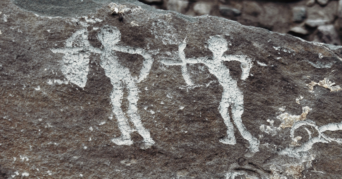
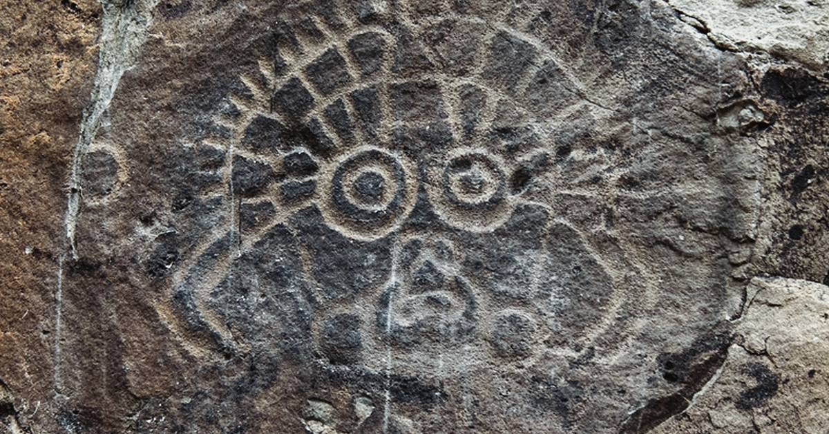
Helankou exhibits a diversified imagery that goes beyond the more predictable animal representations and includes face outlines, hand prints, human figures, symbols and even inscriptions (Xu and Wei 1996) (Figure 2). The site is known for the variety and complexity of its face and/or mask imagery, but the inscriptions are also very significant. The earliest are in Xixia, a script developed for the language of the Tangut Danxiang, the founders of the Xixia dynasty (1038-1227 C.E.), which was centered in Ningxia. These inscriptions relate mainly to Buddhism, the religion patronized by the Xixia. Some of them comment on the petroglyph’s spiritual meaning and associate them with the Buddha, showing that though devoted to Buddhism, the Xixia were in awe of the pre-existing rock engravings. Other inscriptions are repetitions of the name “Buddha,” as if the words were an offering (like the Buddha icons found at countless cave sites), or an actual representation of the Buddha (as is the case at some Chinese Buddhist sites). These inscriptions indicate that Helankou was also a Buddhist site and that some of its later imagery may be connected to that religion. More recent inscriptions are official edicts or records in Chinese dating to the Ming dynasty. Whether in Xixia or in Chinese, these written records must be considered an integral part of the site (Demattè 2011). Their presence in the midst of, and in dialogue with, petroglyphs highlights the interconnectedness of all sign-making and of all practices performed at the site.
This evidence links Helankou to a number of nearby sites that the Xixia dedicated to Buddhist or ancestral devotion. The closest is Baisikou, a Buddhist temple at the opening of a canyon situated few kilometers south of Helankou. Baisikou includes two pagodas, the ruins of a temple and third pagoda, the ancient burial grounds for monks, and a more recent temple building (Ningxia Institute of Archaeology and Cultural Relics 2005). Farther south, but still on the route to Helankou, is the Xixia imperial cemetery, an extensive area (c. 50 square kilometers) on the eastern foothills of the Helan(Han Xiaomang 1995; Steinhardt 1993) that holds the tombs of nine Xixia emperors and over 300 elite burials. The proximity and alignment of these and other smaller sites on the road to Helankou suggests that in the past the entire area may have been akin to a pilgrimage route dedicated to devotional and ritual activities (REF).
Rock art with Buddhist elements is known elsewhere in western China, such as at sites in the Heishan mountains of Gansu province. Even though the Heishan, like the Yinshan, appear rocky and desert-like, its canyons are rich in water and other resources necessary for human survival. Here, rock art locations number in the hundreds and are mostly concentrated in three canyons: Mozi gou, Hongliu gou, Sidaoguxing gou. These are approximately twenty kilometers northwest of Jiayuguan, a Chinese military garrison and outpost at the western end of the Great Wall. This position is significant since Jiayuguan was established during the Han dynasty (206 B.C.E. – 220 CE) to guard a key access pass to the east-west caravan route (i.e. the Silk Road), then threatened by bandits and nomad attacks.
At Hongliugou, petroglyphs were carved at different heights on both sides of the canyons walls and often appear in groups. Most clusters include just a few engravings of animals that are sometimes barely visible, but some larger panels show more elaborate scenes. The engravings feature animals, humans engaged in varied activities, symbols, as well as inscriptions. The themes and iconography suggest that they were probably the product of the ritual and political activities of prehistoric nomads and historic pastoralist populations who successively inhabited the area (Gansu Provincial Museum 1990; Jiayuguan City Cultural Heritage Investigative Team 1972).
A small rock panel representing birds, snakes, bulls and tigers, which are now extinct in the area, suggests that at least some of the Heishan petroglyphs date to the late prehistoric or early historic period of the Chinese northern frontier. These phases are associated with the activities of early inner Asian pastoralists who fought for control of this area up to the time of the Han expansion in the first centuries B.C.E. Some of these groups, such as the Qiang, Xiongnu, and Yuezhi, are mentioned in Chinese sources and are also known from archaeological remains. Metal ornaments and weapons excavated from Xiongnu burials are often decorated with representation of wild animals (particularly tigers) or of animal combat very similar to those visible in rock panels (Di Cosmo 1994; Bunker 1997). Deeper in the canyon, a large panel on a flat rock surface features an elaborate narrative that represents about 30 human figures and a few animals engaged in what could be a dance or performance (Figure 3). People appear to wear long and heavy garments tight at the waist, boots and in some cases feathery or ornamented headdresses. These images may represent the attires of historic Tibetan or Mongolian pastoral nomads, or those of the prehistoric or historic ancestors of these ethnic groups, such as the already mentioned Qiang and Yuezhi (Gansu Provincial Museum 1990).
At a few locations in the canyons, images of camels indicate that carving continued also in later historic times,when the area became increasingly dry and the camel was introduced to substitute the horse for work and transport. These later carving activities are confirmed by engravings that can be dated with more precision. Several images represent Buddhist symbols (such as pagodas, Buddhas, or Buddhist halls) and sometimes carry inscribed prayers in old Tibetan. The images of pagodas are most instructive, because though two-dimensional, they are essentially identical to those found at Buddhist grotto sites in Gansu and beyond. This production falls well into the historic period and ranges from the early-middle Tang (618-906 C.E.) to the Song (960-1279 C.E.) and Yuan (1279-1368 C.E.) dynastic periods (Gansu Provincial Museum 1990). Interestingly, these are not the most recent marks. In the Hongliugou canyon there are also Chinese official inscriptions and Buddhist symbols dating to the Ming and Qing periods. Inscriptions ordinarily are not considered part of rock art, yet their presence here shows how people subscribing to different belief systems claimed the same surfaces and used them in similar ways.
In consideration of the choices that guided the selection of these sites for the construction and use of sacred or ritual places, the rock art locations discussed above can be compared to a number of other sites. Given the themes featured in rock art, the most obvious connection is with Buddhist temples or grotto complexes, particularly those in nearby locations and similar environment. Unsurprisingly, Gansu and Ningxia are as rich in Buddhist temples and rock cut sanctuaries as they are in rock art, though these are rare in Inner Mongolia (Juliano 2002).
Though the construction and use of Buddhist temples and grottoes required specialized technical and ritual knowledge and differs considerably from the creation of rock art, these two types of sacred places share many elements, particularly as regards the choice and use of landscape. Both rock art and Buddhist grotto sites tend to make use of elevated places close to water sources or rivers, and are positioned in remote areas that are, however, within a well traveled network of roads. Like their prehistoric counterparts, which are near prehistoric migration routes and early defensive structures, Buddhist grotto sites were established along the historic Eurasian trade roads and were often in the vicinity of historic fortifications.
Inner Mongolia
For geographic and historic reasons, Inner Mongolia has few Buddhist grottoes, but important temples dedicated to Lamaistic Buddhism are sometimes associated with preexisting nomads’ ovoo stone cairns. Often these stone constructions are near rock art sites and are likely to have been created by the same people who carved the petroglyphs. An example of this confluence of beliefs is embodied by the Chaolu (Black Stone) ovoo stone cairn and Lama temple, which are north of Saiwusu Town, an area of Urad Rear Banner (Inner Mongolia) not far from the Buerhanshan rock art site. At Chaolu, the ovoo complex and the Lama temple share both location and symbolism. The ovoo is decorated with Lamaistic symbols and elements of the iconography of the temple wall paintings are comparable to that of rock art. In one panel, in addition to the Buddha, we see deer and tigers (Figure 4). Though related to Buddhist stories (such as the deer and tiger jatakas), these animals are also a nod to the local tradition of animal representation, which paidparticular attention to deer and tigers. This merging of place and imagery is not surprising, because, since the introduction of Lamaistic Buddhism among the Mongols in the sixteenth century, important ovoos have been incorporated into Lamaistic worship and the most important have become paired with a Buddhist temple.
Ningxia and Gansu
A comparative analysis of petroglyphs and Buddhist art can be carried out by pairing rock art sites with one of the many rock cut sanctuaries are disseminated along the ancient trade routes of Ningxia and Gansu. A good example is Xumishan, a Buddhist cave complex in southern Ningxia, though other Buddhist grottoes, such as Mogao or Binglingsi in Gansu, would be equally valid.
Xumishan holds more than 130 rock cut cave temples spread over a 2 km area on the eastern slopes of Mount Xumi (1800 m, on the Liupangshan range) overlooking the Si River gorge, a strategic pass on a major travel route. The grottoes are clustered into eight groups (Dafolou, Zisungong, Yuanguangsi, Xiangguosi, Taohuadong, Songshugui, Sangeyao, Heishigou) following the main peaks of the mountain (Figure 5). Xumishan, which is not an uncommon name for a Buddhist mountain site, is a reference to mount Sumeru, the sacred mountain of Buddhism (xumi is Chinese for the Sanskrit Sumeru and shan is Chinese for mountain).
Carved out of the red sandstone cliffs and originally fronted by a timber structure, the caves vary in plan and in size based on use and date. Most caves used for worship have a squarish plan and are often equipped with a stupa pillar at the center. However, the largest tend to have side chambers and the smallest often lack the stupa pillar. Caves that served as living quarters for monks are simple, square or rectangular, some with side corridors. The largest cave, the Big Buddha Mansion (cave 5 at Dafolou), houses the tallest statue of the site (20 m), a seated Buddha Maitreya. The smaller ones are just a few meters wide. About 70 of these grottoes were fully adorned with wall paintings or statues of Buddhas, Bodhisattavas and holies carved from the living rock and painted. The remainder appear to have been either unfinished or undecorated, probably serving as the living quarters of monks. Today, only 20 caves still maintain most of their statues and decorations and a few are still in use for both Buddhist and Taoist worship (Ningxia Heritage Preserving Committee & Archaeology Dept. Beijing University 1997).
The cave temples were built in various spurts of activity between the fourth and the tenth centuries under the influence of dynasties, such as the Northern Wei (386-534 C.E.), Western Wei (534-57 C.E.), Northern Zhou (557-81 C.E.), Sui (581-618 C.E.), and Tang (618-906 C.E.), which had an inner Asian or Turkish ethnic background. The main function of the Xumishan caves was as places of worship and pilgrimage. However, beyond devotion, the reasons for this protracted building and use of Buddhist cave temples in an area that is relatively arid and isolated is connected with Xumishan strategic location along the Silk Road, one of the most important Eurasian trade and spiritual routes. Nearby historic and archaeological sites indicate that Xumishan had military and commercial importance over the centuries. A Qin dynasty (third century B.C.) defensive wall near the site and the natural defensive character of the narrow river gorge (where historic battles took place) suggest that Xumishan had considerable strategic importance. Persian and Central Asian objects such as glass and silver excavated from several large burials confirm that long distance trade was thriving on this section of the Silk Road and was vital to the continued use of the grottoes (Ningxia Heritage Preserving Committee & Archaeology Dept. Beijing University 1997).
Notwithstanding its complex sculptural and architectural program, Xumishan resembles rock art sites in many aspects. Like these places, the Xumishan grottoes were concentrated in a series of peaks overlooking a river, and were constructed over an extended period of time by a varied population that included nomad pastoralist, Chinese agriculturalist and their mixed descendants. Though located in what appears as a physically and spiritually remote area, their connections with trade routes and strategic mountain passes indicate that the grottoes were, after all, quite accessible.
All the material remains here &discussed are testimony of the historic role played by the landscape in the shaping of identities and spirituality of local groups, but also of the ethnic and cultural richness of the frontier area. Sacred or other remains ascribable to different groups, from the Han Chinese, to Turkish, Mongolians and other inner Asian nations, highligh the contested nature of these places and the sacrality of the territory for diverse populations. This heritage reminds us that, like today, in antiquity this region was inhabited by a variety people who were actively constructing their home and sacred landscapes. The impression is that, beyond any specific religion, this place could be contrued as “sacred” to many peoples and in different ways.
Indeed, more then individual beliefs, it is the structure of the landscape, real or imagined, religious and political, with its network of routes and visually or materially significant places that creates the sacrality (Bradley 2000, Ashmore and Knapp 1999). Yet, by this very definition, it also shows that the profane is never very far from the sacred and that the “sacred,” though theoretically remote and difficult to achieve, must be accessible and consumable. Elevation and remoteness are attempts at distancing from the everyday, but waterways and travel routes indicate that such distancing was temporary and relative. No matter the structure of belief or its complexity, or whether the believers were roaming nomads who relied on the natural environment for sustenance, traveling merchants who sought respite from it, or urban dwellers who longed for lost nature, particular places acquired sacredness or sacred value because of their positions, structures and cumulative histories.
Fashmore, Wendy and A. Bernard Knapp editors
1999 Archaeologies of landscape: contemporary perspectives. Blackwell Publishers, Malden, Ma.
Baldick, Julian
2000 Animal and shaman. Ancient religions of Central Asia. New York University Press, New York.
Bradley, Richard
1997 Rock art and the prehistory of Atlantic Europe: signing the land. Routledge, London and New York.
2000 An archaeology of natural places. Routledge, London and New York.
Bunker, Emma, Trudy S. Kawami, and Katheryn M. Linduff
1997 Ancient Bronzes of the Eastern Eurasian Steppes. A. Sackler Foundation, New York & Washington.
Cahill, Suzanne Elizabeth
1993 Transcendence and divine passion : the Queen Mother of the West in medieval China. Stanford University, Stanford, Ca.
Casey, Edward
1996 How to get from space to place in a fairly short stretch of time: Phenomenological prolegomena. In Senses of place, edited by Steven Feld and Keith H. Basso, 13-52. School of American Research Press. Santa Fe, NM.
Chen, Zhaofu.
1991 Zhonguo yanhua faxian shi (History of the discovery of Chinese rock art). Renmin, Shanghai.
Chen, Zhaofu
2002 Gudai yanhua (Ancient rock art). Wenwu, Beijing.
Demattè, Paola
2004 Beyond Shamanism: Landscape and Self-Expression in the Petroglyphs of Inner Mongolia and Ningxia (China). Cambridge Journal of Archaeology 14(1):1-20.
Demattè, Paola
2011 Mobile and Settled: the petroglyphs of Helankou, Ningxia, Western China. Rock Art Research 28 (1) in press.
Di Cosmo, Nicola
1999 The Northern Frontier. In The Cambridge history of ancient China: from the origins of civilization to 221 B.C., edited by Michael Loewe and Edward L. Shaughnessy, 885-966. Cambridge University Press, Cambridge UK.
Di Cosmo, Nicola
1994 Ancient Inner Asian Nomads: Their Economic Basis and Its Significance in Chinese History. Journal of Asian Studies 53 (4):1092-1126.
Dong, Yuxiang and Banghu Yue
1988 Binglinsi deng shiku diaosu yishu. In Binglingsi deng shiku diaosu. Zhongguo meishu quanji, Diaosu bian vol. 9, 1-32, Renmin Meishu Press, Beijing.
Gai, Shanlin
1986 Yinshan Yanhua (Petroglyphs in the Yinshan Mountains). Wenwu, Beijing.
Gansu Provincial Museum
1990 Gansu Jiayuguan Heishan gudai yanhua (Ancient rock art of the Heishan, Jiayuguan, Gansu) Kaogu 4:344-359.
Guyuan Museum ed.
2004 Guyuan lishi wenwu. Historical and cultural relics from Guyuan. Kexue, Beijing.
Han, Xiaomang
1995 Xi Xia wang ling (Xixia imperial mausolea). Gansu Wenhua, Lanzhou.
Hong, Y.T., H.B. Jiang, T.S. Liu, L.P. Zhou, J. Beer, H.D. Li, X.T. Leng, B. Hong and X.G. Qin
2000 Response of climate to solar forcing recorded in a 6000-year !18O time-series of Chinese peat cellulose. The Holocene 10(1): 1-7.
Juliano, Annette L.
2002 Buddhist art in northwest China. In Monks and merchants. Silk road treasures from northwest China, edited by Annette L. Juliano and J. A. Lerner, pp. 118-143. Asia Society, New York.
Jiayuguan City Cultural Heritage Investigative Team
1972 Gansu diqu gudai youmu minzu yanhua (Rock art of the ancient pastoral populations of Gansu). Wenwu 12:42-46.
Kleeman, Terry F.
1994 Mountain deities in China: the domestication of the mountain god and the subjugation of the margins. Journal of the American Oriental Society 114(2):226-238.
Ledderose, Lothar
1983 The earthly paradise: religious elements in Chinese landscape art. In Theories of Art in China, edited by Susan Bush and Christian Murck, pp. 165-183. Princeton University Press, Princeton, N.J.
Li, Xiangshi & Cunshi Zhu,
1993. Helanshan yu Beishan yanhua. The Rock Art in Mt. Helan and Mt. North. Ningxia Renmin, Yinchuan.
Little, Steven
2000. Taoism and the Arts of China. Art Institute of Chicago and University of California Press, Chicago & Berkeley.
Munakata, Kinohito
1991. Sacred Mountains in Chinese Art. University of Illinois Press, Urbana.
Naquin, Susan and Yü Chün-fang
1992. Pilgrims and Sacred Sites in China. University of California Press, Berkeley and Los Angeles.
Ningxia Heritage Preserving Committee & Archaeology Dept. Beijing Univ. eds.
1997. Xumishan shiku neirong zonglu (Summary of content of Xumishan grottoes). Wenwu, Beijing.
Ningxia Institute of Archaeology and Cultural Relics
2005. Baisigou Xixia Fangta. Xixia quadrilateral pagoda in the Baisigou valley. Wenwu, Beijing.
Sadakata, Akira
1997. Buddhist Cosmology. Kosei, Tokyo.
Steinhardt, Nancy Shatzman
1993. The Tangut Royal Tombs near Yinchuan. Muqarnas 10:369-381.
Tuan, Yi-fu
1977. Space and Place. University of Minnesota, Minneapolis.
Xu, Cheng & Wei Zhong,
1993. Helanshan yanhua (The rock art of the Helan Mountains). Wenwu, Beijing.
Yuan, Ke ed.
1985. Shanhaijing Jiaoyi. Guji, Shanghai.
→ Subscribe free to the Bradshaw Foundation YouTube Channel
→ China Rock Art Archive
→ The Rock Art of Huashan, China - UNESCO World Heritage Site
→ Rock Art of China's Helan Mountains
→ Yinchuan World Rock Art Museum
→ Itinerant Creeds
→ Rock Art of Inner Mongolia & Ningxia
→ The Tiger in Chinese Rock Art
→ Life in Rock Art by Chen Zhao Fu
→ In Search of a Vanishing Civilization
→ The Rock Art of Wushan
→ Ancient Rock Carvings from Dazu
→ Bradshaw Foundation
→ Rock Art Network