
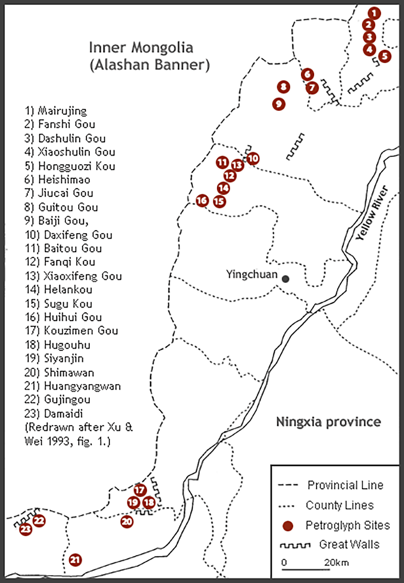
The research paper on Inner Mongolia and Ningxia is a slightly modified version of "Beyond Shamanism: Landscape and Self-Expression in the Petroglyphs of Inner Mongolia and Ningxia (China)" published by the Cambridge Archaeological Journal (2004). Any citation reference should be made to the original article which can be found here.
Petroglyph sites in the Yinshan and Helanshan ranges were documented during a recent survey. Archaeological remains indicate that these areas have for millennia been both militarized borders and osmotic trading zones connecting the pastoral people of Northern Asia and the Chinese world. Petroglyphs form a significant part of the material and symbolic culture of this transitional zone from the Neolithic down to the later dynastic phases (nineteenth century).
By using newly-gathered data, this article moves away from interpretations which see rock art as a wholly shamanistic phenomenon, introducing territory and iconography as key elements for the understanding of local geographies, cultural interactions, and the agencies of identity. The location of the sites indicates that petroglyphs were next to travel routes and may have served as territory markers and meeting places. In addition, the scattering of marked rocks in key locations suggests that petroglyphs were markers of identity essential for a people who were engaged in a dialectic contention with the expanding agricultural world. The sense of identity can be perceived also in the subject matter (wild and domesticated animals, hunting and herding scenes, faces) which seems to emphasize respect for, or even enjoyment of, pastoral and nomadic life.
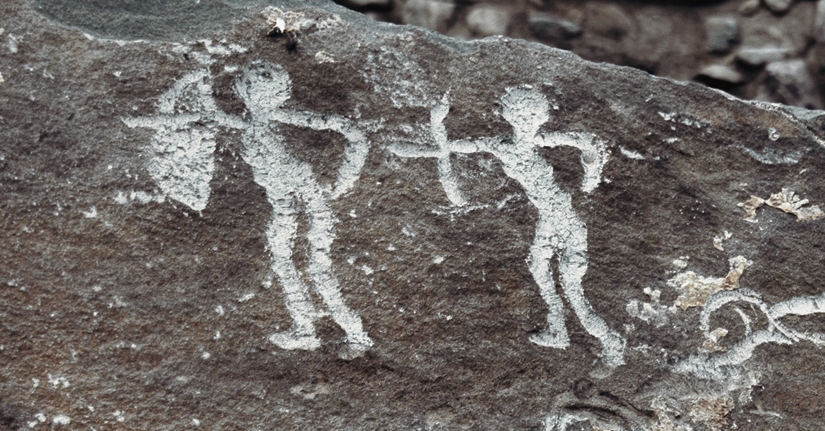
 Figure 4
Dishui Gou petroglyphs (Urad Rear Banner, Bayannur League)
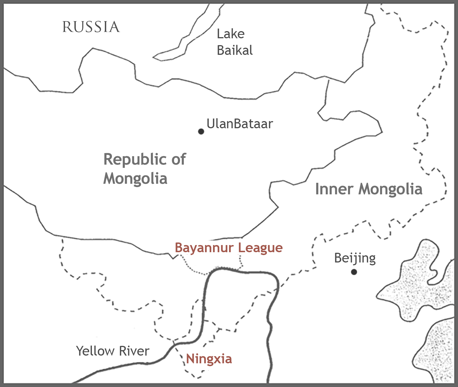
The rock-art sites of south-central Inner Mongolia and nearby Ningxia Province, which share a cultural unity, are the richest and best-documented of the Chinese northern frontier (Gai Shanlin 1985; 1986; 1989; Xu Cheng & Wei Zhong 1993) (Fig.1 & Fig.2). In Inner Mongolia, rock-art sites concentrate in the west-central area (the Alashan desert and the Yinshan, or Yin Mountains, and to a lesser degree in the Wulanchabu grassland to the north of the Yinshan). In Ningxia, a smaller province south of central Inner Mongolia, rock art is centred in the Helanshan (Helan Mountains). In both provinces, the majority of rock art consists of petroglyphs, even though a few painted images are documented. My own reconnaissance in June 2000, which covered ten sites in three locations in the Yinshan and the Helanshan, forms the basis of this study (Fig.1 & Fig.2).
Urad Rear Banner/Wulate Houqi
(Bayannur League/Bameng)
 Figure 3
Bu'erhan Shan petroglyphs (Urad Rear Banner, Bayannur League)
Dishui Gou is on a high ledge inside a narrow ravine along the southern edge of the Yinshan (Bayinbaolige village) (Fig. 2:2). The signs consist mostly of circular patterns, perhaps pseudo-human faces or masks, deeply carved on the sides of the gully (Fig.4). The gully is dry during the summer, but in spring seasonal waters bless the area, and at the neck where the images are found, the waters are forced through a narrow passage producing a waterfall. The position of the images on the highest cliff faces affords also a remarkable view of the fertile territories further south.
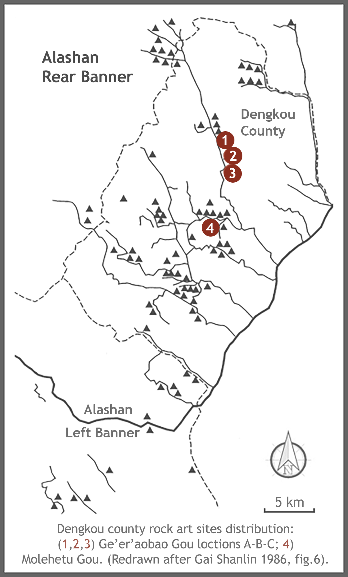
Dengkou County
(Bayannur League/Bameng)
 Figure 6A
Ge'er'aobao Gou
Ge’er’aobao Gou is a wide sandy canyon opening towards the fertile land formed by the flooding of the Yellow River (Fig. 15:B). Within the canyon are petroglyphs, burials, worship areas, habitations (old and recent) and springs. These water sources are associated with petroglyphs and small shrines. Archaeologists have collected Han pottery and Xixia (AD 1038-1227) porcelain, an indication of active trade over extended periods (Gai Shanlin 1986, 205-7). Petroglyphs are in dense concentrations on the steep walls of the eastern side of the canyon, and tend to be engraved on large slabs facing west or south or up walls Explain. Three locations running in close succession (A-B-C) are most remarkable.
 Figure 6B
Petroglyphs at Ge'er'aobao Gou (Dengkou county, Bayannur League, location C)
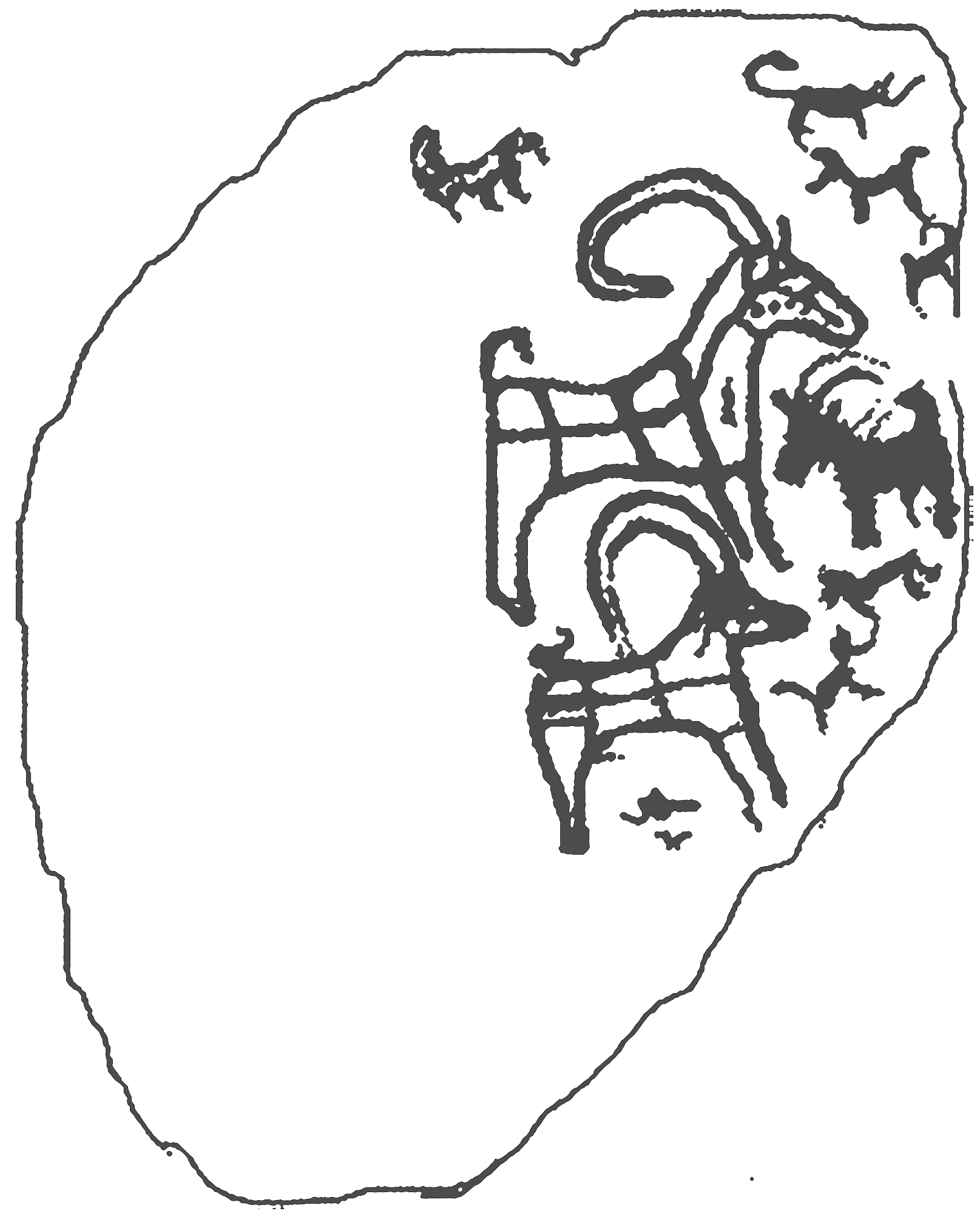
Molehetu Gou, which is narrower than the main canyon, branches almost perpendicularly off the west side of Ge’er’aobao Gou and runs north-west. Here there are 5 main petroglyph sites: 4 on the northern cliff sides, and one on the southern side. The southern site is a rocky hillock about 50 metres high in front of which runs a creek. The petroglyphs cover the sloping area from the bottom of the hill to near the top across a width of about 100 metres. Its iconography consists mostly of deeply engraved faces or masks and 'abstract symbols', even though there are also standard animal figures and group scenes (Fig.7).
Shizuishan City
The Heishimao site is in northern Ningxia (Fig.8:6). The area is mountainous, but only the Heishimao hill is dotted by stones with a dark and shiny desert patina suitable for petroglyph carving. The engravings are concentrated at the summit, and consist mainly of single pictures of animals (mountain goats and deer) (Fig.9). The petroglyphs are difficult to see because weathering has cloaked the incisions with a dark patina similar to the stone surface. This may indicate an early age for the signs, even though their fading could be due to the superficiality of their incision.
Pingluo County
 Figure 10
Tiger petroglyph from Daxifeng Gou
One location about 5 km from the canyon mouth consists of a series of carvings on a horizontal slab a few metres above the bottom of the gorge. The slab is not very large, but the theme of the carvings is of great interest since it represents tigers (a rarely represented animal) in a style resembling that of the third- to fourth-century BC Ordos bronzes of northern nomadic and semi-nomadic origin (Fig.10; cf. So & Bunker 1995, 111 fig. 26, 116 fig. 30.2). According to archaeological reports, about 10 km along the canyon there are the remains of a Xixia citadel (huangcheng), a sign that the canyon was a routeway of military importance in historic times.
Helan County
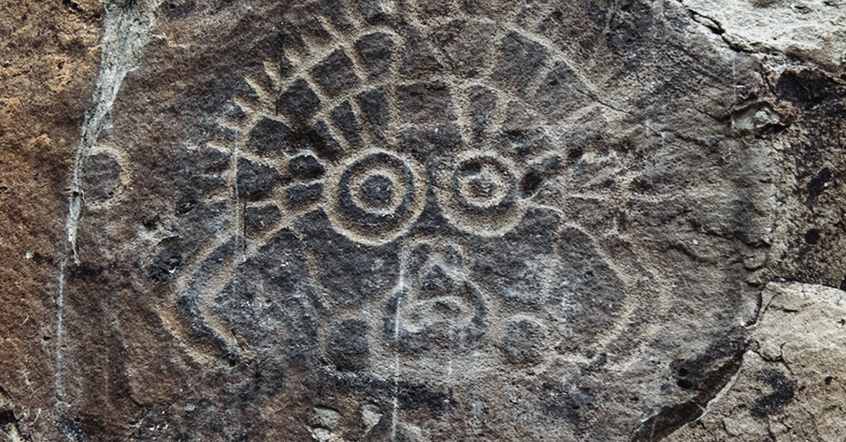
 Figure 11
Mask motifs at Helankou
Qingtongxia City
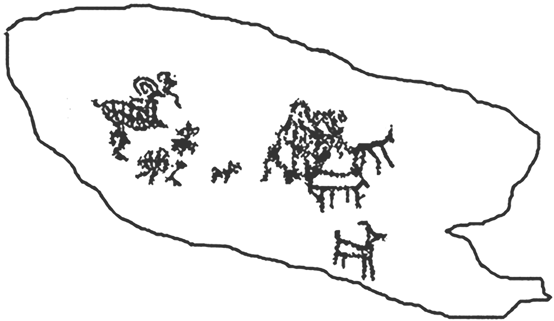
The area of Siyanjin (literally 'Four Wells') is a stony and undulating desert at the southwestern edge of the Helanshan. Portions of the Ming period Great Wall are visible at various points, as are shrines dedicated to folk deities and springs (Fig. 8:10). There are several petroglyph concentrations in this desert territory. Three deserve attention: (A) a hill at the beginning of the gorge area; (B) a hill further up the main gorge; and (C) a slab at the bottom of the mouth of a small side gorge. Location A includes mostly images of animals (horses, camels and goats) in abbreviated style and some apparently abstract symbols (circles, stars, squares) (Fig.12A). Location B has a higher concentration of bird figures and abstract symbols (Fig. 12b). The styles of the carving at these two locations appear to be very similar: both are characterized by rough carving and unsophisticated imagery. Location C stands out in terms of style and imagery: a large animal (possibly a carnivore) with two herbivores in its stomach (Fig. 12c) is apparently attacked by a small human. Whether the images were carved together or are the result of a palimpsest it is unclear; however, the custom of portraying the inside of an animal (the so-called X-ray style) is not uncommon in much prehistoric art. At this location, the carvings are deeper, thinner, more regular, and apparently older than at locations A and B, but some signs appear to have been re-carved.
Zhongwei County
 Figure 13B
Gujingou petroglyphs (Helanshan, Zhongwei county, Ningxia)
A) a low hill topped by dark stone slabs covered by signs ranging from simple and superficially engraved single animal, to deeply carved or engraved 'scenes';
B) a horizontal slab approximately 4 metres long in a seasonal river bed, with associated boulders. The slab is completely covered by signs, mostly weathered, representing simple scenes involving animals and humans; the stones are better preserved and depict human faces and animals. (One features a deeply carved horned sheep with decorated body or X-ray display standing amid other animals: Fig.13A.)
C) consists of several flat-faced boulders of dark colour atop a low hill. One is carved with a hunting scene featuring several horned animals and a hu-man armed with bow and arrows (Fig.13B).
At Damaidi, like at Gujingou, petroglyphs are concentrated on outcropping dark rocks atop small hills. Images vary in content, style, carving technique and patina. Hunting and riding scenes with people carrying bows and arrows and scattered animals (generally horned) are very common (Fig.14). Variations include representations of the chariot, of which there are at least two examples (Fig. 14), and an image of a human, apparently with an aura or a circular headdress, riding a strange creature or a sleigh. In addition, there are a few faces or masks carved in a summary way, which may be more recent.
 Figure 14A (left) & Figure 14B (right)
Damaidi Petroglyphs
According to Gai Shanlin (1986, 343-8), petroglyphs in Inner Mongolia span the time period from the early Neolithic (c. 8000 BC) to the later dynasties (nineteenth century). Nonetheless, accurate dating and ethnic attribution of these carvings is only partially possible, given the insufficient amount of archaeological data and the limitation of dating methodologies. Dating relies on traditional methods, such as stylistic comparison with excavated artefacts; presence/absence of extinct or domesticated animals and new technologies; carving techniques; tools; superimpositions; and inscriptions and historical records (cf. however Li Xiangshi & Zhu Cunshi (1993, 319-24) who discuss lichen dating).
Since Inner Mongolia and Ningxia share many cultural traits, Gai Shanlin's proposed chronology for the rock art of the Yinshan helps also with the dating of the Helanshan petroglyphs (Xu Cheng & Wei Zhong 1993, 376-87). Gai identifies three major periods of Yinshan rock art: 1) Neolithic - Early Bronze Age (8000-1000 BC); 2) Later Bronze Age - Early Iron Age (1000 BC-AD 200); 3) Historic (AD 500-1900). In the Helanshan, Xu and Wei also identify three periods even though these begin slightly later than Gai’s and are tied to the Chinese chronology: 1) Shang-Zhou dynasties (1600-200 BC); 2) Qin-Han and Northern-Southern Dynasties (200 BC-AD 600); 3) Sui-Tang, Xiaxia, Mongol Yuan (AD 600-1900). Save for minor differences, the proposed periodizations and stylistic developments of the Yinshan-Helanshan petroglyphs agree with each other and with those identified for Mongolian (Nowgorodowa 1980), and North and Central Asian rock art (Martynov 1991; Francfort 1998). The periodization proposed by Gai Shanlin is accepted here as a working tool (even though it needs improvement). Gai’s periodization may be considered preferable to that suggested by Xu and Wei because it focuses on the Northern Zone material culture and history, rather than on the Chinese dynastic chronology.
In dealing with this chronology it is nonetheless helpful to keep in mind a few key points. First of all, dating of petroglyphs is suggestive rather than firm, and therefore should be taken with a degree of flexibility. Second, but most crucial, all the sites described above exhibit petroglyphs which stylistically appear to date to different phases, thus suggesting that these were areas in use for protracted periods and that the visible images form time-layered palimpsests. Third, notwithstanding this extended production, the bulk of the petroglyphs date to Gai’s second period, which is the time of highest pastoral-nomadic activity in the area. So even though some sites may have a higher concentration of one type of sign it is not feasible to date a site to one single phase.
Gai's first period, Neolithic-Early Bronze age (8000-1000 BC), is subdivided into three phases: early (8000-4000 BC), middle (4000-2000 BC) and late (2000-1000 BC). He ascribes these to Early Hunting; Developed Hunting and Primitive Farming; and Early Pastoralist phases of subsistence. In the first phase, animals represented include Megaloceros, ostrich, and deer (Elaphurus davidianus), which became extinct in the area early in the post-Pleistocene. The second phase, in addition to representations of different animals (ibex, blue sheep, red deer, brown bear, reindeer), exhibits for the first time human representations either as full figures or as (pseudo-human) faces in frontal view (i.e. Helankou). The dating of these faces to this phase seems secure for reasons of style, weathering, patination, and carving techniques (Chen Zhaofu 1990), and by comparison with similar images from North and Central Asia (Martynov 1991;
Hoppál 1992; cf. however Francfort 1998). The third phase includes representations of the first domesticated animals, such as horses, cattle, sheep, donkey, as well as wild animals which continued to be hunted. Given the limited information available, the rock art of this early period can only be tentatively attributed to pre- and proto-historic populations documented archaeologically, but it is clear that their cultural background was similar to that of later hunter-pastoralists who occupied the same areas.
Gai's second period, Bronze Age-Early Iron Age (1000 BC to AD 200), comprises two phases: Early Animal Husbandry and Hunting, and Developed Animal Husbandry. A distinctive characteristic of this period is the presence of 'scenes' with multiple actors and a narrative twist, rather than single isolated figures. In the first phase are representations of herding and warfare, and the appearance of important time markers like the cart and the camel.1 The second phase includes pictures of herds surrounded by railings (evidence of developed husbandry), horseback riding, saddled horses (generally without stirrups), war chariots, bow and arrows, weapons at the waist, and an increasing number of camels.2 The petroglyphs of this period form the bulk of the production at the Yinshan, and those of the second phase have a tentative ethnic affiliation. From comparative stylistic analysis with excavated artefacts Gai ascribed them to the Xiongnu people, who were active, here and in south Siberia and Mongolia, from the third century BC to the first century AD. After this period the area was occupied by the Xianbei (AD 150-400), a phase which inexplicably Gai Shanlin does not discuss, but which rightfully also belongs to this general period (cf. Xu & Wei 1993).
The third period of Gai’s chronology (the Historic period) includes the petroglyphs produced by various ethnic groups from the sixth to the nineteenth century. This is to be understood as China's northern frontier historic period, which starts with the adoption of writing by the Tujue Turks in the sixth century. Following the demise of the Tujue in the eighth century, the area was occupied by the Tufan, the Huihu, and the Tangut Danxiang who established the Xixia dynasty. Lastly, in the thirteenth century, the Mongols, who swept across China and created the Yuan dynasty, settled in this area, where they have remained until today. The rock art of this period is characterized by a shortened (almost cartoonish) style in the representation of both human and animal figures, shallow carvings, use of iron tools, and co-mingling with inscriptions (in Turkik, Mongolian or Tibetan scripts). Gai Shanlin, Xu Jie and Wei Zhong, consider this the phase of decline of the Yinshan and Helanshan rock art tradition, a fact which they attribute to the introduction of writing and the shift away from pictures towards the written word.
This periodization of rock art finds a degree of support in the archaeological record of the Chinese northern frontier, though given the limited amount of excavation and survey specifically in the Yinshan-Helanshan area, associations between archaeological remains and rock art are tentative. Archaeological evidence relating to the local Neolithic is scant as little excavation has been carried out in these specific areas. Some scholars argue that in the Helanshan and in Ningxia, evidence of settled life indicates that the area was part of the greater Yangshao cultural system, and specifically of the Majiayao and Qijia types (both fully settled and agricultural) (Li & Zhu 1993, 11). From probing at about 30 sites, the Ningxia Neolithic seems however to have been characterized by the northern microlithic tradition (with evidence of a ceramic tradition and settled life). Excavations in the southern portion of the province, at the sites of Caiyuan (Haiyuan county) indicate that while contemporaneous with Majiayao, the Caiyuan culture had very distinctive regional traits, which eventually were to influence the development of the later (Bronze Age) Qijia culture (Ningxia Cultural Relics Bureau 1999, 468-9). This preliminary evidence attests that there was at least some degree of difference between the Neolithic of Ningxia and that of the fully agriculturist societies of the Wei River valley further to the south.
As for Inner Mongolia, given the size and geographical diversity of the territory, a variety of cultures are known. In the Neolithic, the differences between cultural clusters are more apparent, but the trend is towards homogenization, so that towards the Late Bronze Age many similar traits are apparent from west to east (cf. the Northern Zone complex, Di Cosmo 1999, 893). A well-documented Neolithic sequence (Xinglongwa, Zhaobaogou, Hongshan, Fuhe, Xiaoheyan) has been established for eastern Inner Mongolia (Nelson 1995; Inner Mongolia 1999). Less is known about the Neolithic of the south-central part of the province and specifically the Yinshan, but a preliminary sequence (Lower Wangmushan 4000 BC, Haishengbuliang culture 3000 BC, Miaozigou culture, Laohushan culture 2000 BC) has been established for the Haidai and Yellow River area to the southeast of the Yinshan. This evidence points to the existence of a mixed agricultural and herding economy.
For the later period, excavations in the Yellow River and Ordos regions of Inner Mongolia have brought to light the remains of the Early Bronze Age cultures of Dakou and Zhukaigou (c. 2000-1200 BC). The Lower Xiajiadian complex (c. 1800-1400 BC) is instead attested in the eastern part of the region (Bunker et al. 1997, 18-28; Di Cosmo 1999, 897-8; Inner Mongolia 1999, 83-8), where evidence shows also the development of elaborate ceramics and of fortified settlements. In a later phase (1000-600 BC) in the same area, bronze production played an important role as documented from excavations of Upper Xiajiadian sites in eastern Inner Mongolia and related northern cultures (Shelach 1999, 143-76; Bunker et al. 1997, 18-98).
Following the end of the Upper Xiajiadian (from 600 BC), the area enters a period characterized by protracted and historically-documented interaction between nomadic populations (the already mentioned Xiongnu and Xianbei) and the Chinese world of the late Zhou and Han (c. 500 BC-AD 300) (Ishjamts 1992; Shiji 1972, 2879-920 Xiongnu Liezhuan 50, ch. 110, vol. 9). The attribution to the Xiongnu of a good portion of the rock art of the Yinshan (and possibly of the Helanshan) is not without reason: many of the petroglyphs show a considerable stylistic and thematic similarity with the metalwork styles (belt buckles, knives, daggers, horse fittings) discovered in Xiongnu contexts (Wu En 2002). They include the so-called striation or X-ray style (with animals covered by lines representing their skeletons or their mantle), and the animal-combat motif in which animals are shown in a deadly embrace (Kessler 1993, 37-65 figs. 35-6; Bunker et al. 1997; Rawson 1990). The Xiongnu were wiped out in the second century AD by a new nomadic power, the Xianbei (AD 150-400), an ethnically mixed group which practised both pastoralism and farming. As the Xianbei occupied these areas they absorbed some of the Xiongnu population and seem to have been influenced by their material culture. Like the Xiongnu, the Xianbei were very likely responsible for considerable petroglyph production, even though their contribution is hard to distinguish stylistically and iconographically from that of their predecessors (Kessler 1993, 75-6, figs. 46-48).
Rock art is often perceived as a manifestation of the spiritual activities of our ancestors, and religion and ritual have historically played a major role in its interpretation. In the past, petroglyphs were explained as representations related to the world of 'primitive' religion (shamanism, animism, etc.) and specifically to rituals of hunting and fertility magic (Breuil 1952; Lommel 1967; on Lommel 1967).
In China, rock art is still at times interpreted by the older generation of Chinese scholars in terms of fertility and/or nature cults (Ban Lan 1991), but new ideas are also taking hold. Gai Shanlin and others (Chen 1988, 163, 1990) see some petroglyphs of Inner Mongolia and Ningxia (faces and circular signs with radiating patterns) as representations of sun-deities and evidence of a sun-cult. Comparable signs from northern Asia are similarly interpreted by the Russian Martynov (1991, 41-3), who sees them as solar symbols associated with imported Indo-Iranian cults. Most of the arguments in support of the fertility and nature cult hypotheses are based on speculation or evidence drawn from the Neolithic tradition of the Yellow River valley, which is culturally and geographically remote from the Yinshan and Helanshan (Gai 1986; 1989; Li & Zhu 1993). These beliefs cannot be ruled out (particularly the sun-cult, which may be connected with the sun-and moon-worshipping documented among the Xiongnu and Tujue), but the nature of these beliefs and how they would have informed the creation of petroglyphs is unclear (cf. Francfort 1998).
In Western scholarship, the 'structuralist' phase has been replaced by a return to shamanism as an interpretative framework for rock art, though the emphasis has shifted away from fertility and hunting magic towards altered states of consciousness (for a summary see Bahn & Vertut 1997, 180-83, 189-97). Current shamanistic interpretations take a narrow view of the shamanic processes and see rock art (and even Paleolithic cave paintings) simply as the creation of shamans who after trance experience (induced by obsessive dancing, fasting, or hallucinogenic drugs) depict their visions on stone. While there are and there have been a number of variants in shamanistic theories of rock art, the so-called 'neuropsychological' model, put forth some time ago by Lewis-Williams & Dowson (1988) is probably the one that has had the greatest impact in the field of rock art studies.
The 'neuropsychological' model claims that the tell-tale marks of the shamanistic trance experience in rock art are abstract carved or painted signs (grids, dots, zig-zags) in proximity to or embedded in the petroglyphs. These abstract signs are interpreted as entoptic phenomena (phosphenes and form constants), which according to Dowson and Lewis-Williams are pseudo-images created by the optic system under duress (in this case shamanic trance). The entoptics are said to mix and coalesce with 'true iconic' (and culture-specific) hallucinations during a three-stage trance experience.
If we may presume that those who hallucinate see entoptics and record them in images, the presence of grids, dots, and zig-zags allows the proponents of the model to identify rock art as a by-product of hallucinatory visions by people who have experienced trance (the so-called 'shamans'). Other signs of shamanistic vision are said to be the presence of therianthropes (interpreted as a self-vision of the shaman in trance) or simply of animals (the shaman completely transformed) (Lewis-Williams & Dowson 1988). At this point it is clear that if we were to follow this interpretation, the Yinshan and Helanshan rock art could easily be construed as shamanistic. Neverlethess, such a threshold for the identification of shamanistic iconography is very low, so that virtually any sign can be understood as a by-product of shamanism. This is the first of a series of weaknesses of the 'neuropsychological' model.
The second relates to its scientific support. The advocates of shamanism use neuro-psychological theories to suggest that their model is based on scientific evidence applicable to all modern humans and may be used to explain rock art the world over, notwithstanding cultural, geographic and temporal differences. Specialists in the field have over the years voiced great perplexity about these claims and the dated literature used to substantiate them. Specifically, neuro-psychologists are troubled by the proponents' understanding of entoptic phenomena, the existence of a three-stage trance experience, and the drugs available in antiquity that could induce the sort of hallucinations described in the model (Bahn & Helvenston 2002).
The third weakness comes from the simplistic use of ethnographic analogy. This model interprets the 'entoptics' in the light of nineteenth century ethnographies relating to groups of South African San from desert areas who were known to have practised shamanistic activities involving hallucinatory trance (Lewis-Williams 1983). Since these San groups did not historically occupy rock art areas, however, it is debatable whether they were producers of rock art, and, if not, whether their religious activities were similar to those of the groups who actually created it (Salomon 1998; Jolly 1998). Other evidence is gathered from ethnographies concerning Native North Americans, who are known to have engaged in shamanistic activities (Whitley 1992), even though these sources also do not seem to indicate that shamanism was the only reason for the creation of rock art (Grant 1967, 28-39; cf. also Layton 2000). In a repeat of the fertility magic theory, ethnographies are employed to present rock engravings as a homogeneous religious phenomenon shared by all 'primitives', from the European Palaeolithic hunters to the San of southern Africa and a variety of Native American groups. The message seems to be that while 'high' civilizations have complex religions and religious iconographies, the ‘primitives’ of all times and places have one religion and one iconography.
This approach leaves no room for appreciating cultural idiosyncrasies and different perspectives on meaning, since it is rigid in its identification of shamanistic trance as the sole cause for rock art, and loose in its definition of 'shamanism', which is confused with mystical aspects inherent in many religions. The looseness in the definition of shamanism and the randomness of the application of the shamanistic interpretative framework in matters of prehistoric iconography (not only in rock art) has generated great dissatisfaction in the scholarly community (Francfort & Hamayon 2001; Klein et al. 2002), particularly among those who take seriously the study of this phenomenon.
The issue of shamanism is of growing importance to Inner Asian rock art studies (Rozwadowski 2001; Devlet 2001; Francfort 1998), and given the location of Inner Mongolia and Ningxia at the edge of Inner Asia, the locus classicus of shamanism (Humphrey & Onon 1996; Eliade 1964), a possible role of shamanism in the Yinshan and Helanshan rock art cannot be ignored.
Sources indicate that the populations of these areas worshipped a variety of spirits with different rituals, and that 'shamanism' was only one aspect of their belief system. According to Chinese documents, the Xiongnu, Xianbei, Tujue, Mongols and other populations who occupied the area before the introduction of Lamaistic Buddhism in the sixteenth century, worshipped heaven (mong. Tängri), earth, the sun, the moon, and the spirits of local mountains and rivers, and practised cults of the ancestors with varying degrees of complexity (Heissig 1970, 1992). Tängri was generally the focus of the belief system, and since humans could not approach it directly, the ancestors were essential in bridging the divide. To contact their ancestors or be cured, people employed a ritual specialist (the so-called shaman); there were however other rituals (such as propitiating the spirits of earth and water), which were carried out without shamans (Ishjamts 1992; Lin 1988, 117-128; Zhoushu Liezhuan 42, juan 50, 1971, 907-12, vol. III; Humphrey 1994; Soucek 2000, 103-16; Baldick 2000, 93-125). This overview shows that while there probably were shamanistic activities among the people of the Yinshan and Helanshan, the ancestors enjoyed a higher position than the shamans in the religious hierarchy and had greater power to connect with the supreme Heaven.
Before the sixteenth century, the local religion centred therefore on ancestor worship and the cult of heaven, with shamans as mediators (Fedorova 2001). With the introduction of Buddhism, the belief system was transformed into a syncretistic religion which combined Lamaistic and pre-Buddhist elements. Within this new system, the shamans either 'converted' and played a role as lamas, or were pushed to the margins (Heissig 1970).
Some evidence from the Yinshan-Helanshan rock art may indicate a ritual concern (the choice of special places, the presence of anthropomorphic faces or masks radiating rays, or the repetition of certain animals). Given the local religious circumstances, one would expect these signs to be associated with either ancestor/heaven worship or with Lamaistic Buddhism, rather than with some abstract form of shamanism. As we will see below, this appears indeed to be the case, even though it does not mean that petroglyphs were never associated with shamanistic activities. Visual imagery was of great im-portance for Inner Asian shamans (Siikala 1992c; Devlet 2001). Vilmos Diószegi (1998) has shown how the drawings inside Teleut and Baraba Turks shaman drums represent the cosmos and the animal helpers who guided the shaman in otherworldly journeys. Russian researchers have identified petroglyphs from the Tom' River (Siberia) which may depict shamans, though according to Hoppál (1992c, 139-40) only a few figures in costume holding drums and dancing can be positively identified as such.
One might accept the activities of the shaman (or other religious leader) as a significant force behind the production of rock art relating to a certain belief system. It is necessary, however, to keep in mind: 1) that the relationship between this agent and the making of the images need not have been direct; and 2) that the function of the imagery was very likely multifaceted, extending beyond the strictly religious.
The religious significance of petroglyphs, if present, may have resided in the offering or commissioning of images, rather than in their actual production, and the makers or commissioners of the images could have been devotees or specialists. The images' function may have been related to devotional practice, recording religious events, or didactic narratives with mythical, legendary, or even historical overtones (Hoppál 1992, 138; cf. also Salomon 1998). These uses of images in religious context are commonplace in much religious art of so-called 'higher' civilizations, but they are rarely taken into consideration in rock art studies. Buddhist rock art can be very informative about the processes which bring religious images into existence. Its different forms of expression range from representation of Buddhas and Bodhisattvas to portraits of donors and narratives about legendary and historic events. These open our eyes to the multiple meanings which could hide behind rock art. Interestingly, evidence of such devotional offering of images is found in the Helanshan rock art. At several sites in the counties of Qingtongxia, Zhongwei and Shizuishan there are engravings of small pagodas resembling the ceramic pagoda models which in acts of devotion were buried by pastoralists devoted to Lamaistic Buddhism.3 This evidence seems to indicate that, at least in this instance, the carving of an image on a rock corresponded to the act of offering by burying an object. In other places, such as Helankou, inscriptions of the Buddha’s name seem to be addressing or invoking this figure, so that the written characters became the actual focus of worship (Xu & Wei 1993, 83-5).
While there is indication that petroglyphs were sometimes associated with religion and ritual, other evidence shows that they were also the focus of more prosaic activities. Ethnographic sources for Inner Asia (Hoppál 1992), Europe (Siikala 1992), North America (Grant 1967, 28-39), South Africa (Jolly 1998; Salomon 1998), and Australia (Layton 1992) show that rock art was produced and used in a variety of contexts ranging from the ritual-religious to the mytho-historic to the utterly secular (mnemonic signs or even doodles). While the ritual-religious aspect may have been predominant, it covered a wide variety of subjects including rain, hunting, puberty, fertility and initiation rituals, which did not necessarily involve 'shamanistic' activities. In fact, in North America among the Thompson River Indians of British Columbia or the Nez Percé of Idaho, puberty pictures were painted by the boys and girls who were undergoing initiation rituals (Grant 1967, 28-30). According to Hoppál (1992), in Eurasia lay participants in open-air rituals often engraved their symbols on the rock to indicate that they had been there. Australian aboriginal culture provides another good example of the complexities associated with rock art and ritual-religious activities. The comparative wealth of knowledge about Australian rock art and about the significance of its iconography that comes from informed interpretation indicates that these images were created (in religious or secular contexts) to record clan myths and claim sacred locations or significant land resources by the idea of presence (Layton 1992, 74).
This shows that even if religion plays a role, other crucial aspects are involved in the creation of images on rocks, and these often have something to do with issues of group identity, land ownership, boundaries, and the semiotics of communication (Hoppál 1992c; Nordbladh 1979). In conclusion, even though Inner Mongolia and Ningxia are in a legitimate cultural and geographic context for shamanism, shamanism (and religion more generally) is a limited and insufficient framework for interpreting the rock art of these regions. The potential for an understanding of petroglyphs not only beyond shamanism, but also beyond the purely religious, is therefore apparent. While often connected to religion, visual imagery is a phenomenon which has ramifications beyond that narrow confine: the nature of petroglyphs as culturally significant signs produced and used in the landscape makes them likely candidates for a variety of other meanings and uses.
To go beyond the limitations of a purely shamanistic approach, it is essential to look at the empirical evidence. Elements relevant to the interpretation of the local petroglyph tradition can be gleaned by observing the environment (natural or built) of these signs, their spatial distribution and relationships, their physical nature, and their iconography.
Landscape and Space
Landscape is the aspect which deserves the greatest attention, since it is often related to issues of movement, identity, appropriation, learning and sacrality in relation to place (Whitley 1998, Ouzman 1998, Hartley & Wolley Vawser 1998). Though petroglyphs are scattered over large parts of Inner Mongolia and Ningxia on the Chinese northern frontier, they concentrate in two main mountain ranges: the Yinshan and the Helanshan (Fig.2). The Yinshan run east-west like an arch above the great Yellow River bend for over 1000 kilometers, and reach heights of 2000-2300 metres above sea level (from the plateau height of about 1000 m). Today, this area is extremely dry, but historical and archaeological evidence indicate that in the past it was much more fertile. The Helanshan, to the south of the Yinshan, run north-south to the west of the great Yellow River bend and separate Ningxia from the western portion of Inner Mongolia (Alashan Banner). The proximity of the Yellow River and the protection of the Helanshan have made the plains of Ningxia a cultivable and desirable land, which various Chinese dynasties took trouble to defend from nomads by building portions of the 'Great Wall' on its western and eastern borders. One section runs along the Helanshan.
These mountain chains, while not particularly high, create a natural barrier which protects from winds and sand the fertile regions to their south and east. In the past, they offered easy movements through the canyons to nomads and traders. It is conceivable that these mountains were chosen as petroglyph sites, not only because they provided the stone surfaces necessary for carving, but also because their canyons were on the communication routes which connected the world of the steppe with China, and constituted a home environment at least for the nomads. Archaeological and textual evidence shows that trails of the so-called northern Silk Route passed through these areas and that the local nomadic populations engaged at different points in time in commerce at established trading posts. These exchange activities brought a considerable number of artifacts of 'Western' provenance to the region (Juliano & Lerner 2002). The canyons were also crucial to these nomads' creation of their own identity, and to their cultural and economic universe, particularly in the historical period when they came under increasing pressure from the Chinese agricultural world. With the expansion of settled life, the Yinshan and Helanshan tended to different economic life-styles: pastoralist in the north and agriculturalist in the south. Already by the late Zhou period (fifth century BC), one of the Chinese Warring States, Zhao, built a defensive wall on the southern edges of the mountains, thus creating one of the northern frontiers of the China. With the Qin (221-206 BC) empire and later the Han (206 BC-AD 220) (who built outer walls beyond the Yinshan), the boundary was well established and defended by sections of the so-called 'Great Wall', garrison cities and beacon towers (Gai & Lu 1981a).4
These fortifications, which are often closely associated with petroglyphs, appear as symbols of the settled empire and markers of a defined frontier, but at the same time they suggest connections between people on the different sides. The remains of two lines of the outermost early Han (c. second century BC) walls in Chaoge Banner run almost alongside the modern border with the Republic of Mongolia. This wall was reportedly built at the request of Emperor Wu of the Han to contain the Xiongnu and was defended also by military garrisons, such as the nearby Chaolukulun stone citadel (Chaoge Banner), or further away at Jilusai (Dengkou county) (Gai & Lu 1981b; Bayannaoer 1987, 263-4). The wall itself was a modest defensive structure made of stones, sand and pebbles (2 m high, 1.5 m wide) meant to stall an initial attack of nomadic cavalry, while a series of watchtowers farther south would have alerted the garrisons, and the Chinese army (Gai & Lu 1981a; Yu & Cheng 1980, 26, 98, 100-102). This policy of containment and wall construction continued throughout Chinese history and later and more massive walls (Ming) are visible in at various points of the Helanshan (Fig. 8).
The presence of Chinese fortifications in proximity to both mountains and petroglyphs, and the role of the Yinshan and Helanshan ranges as natural and perhaps symbolic borders, raises the issue of the encounter between the Chinese agricultural world and the Asian pastoral nomads. While for over 3000 years the northern and western nationalities have been portrayed in Chinese historic sources as barbaric intruders, it was actually the Chinese settled world that already by Shang times (1600-1100 BC) was expanding from the middle-lower Yellow River Valley onto lands that had traditionally been pastures (Chang 1980, 254). The nomads were attempting to escape the raids of Chinese settlers, while trying to hold onto the lands that provided them with resources not available further north: water, good pasture, and some grain.5
Even though scholars past and present have seen the relation between settled and nomadic populations as inherently hostile owing to the nomads' 'envy' of the wealth of settled people and lack of understanding of farming, more recent studies indicate that the differences were not always so well marked and that contacts were constant and productive for both sides (Di Cosmo 1999; Jagchid 1989). Agricultural expansion into nomadic territories is documented in various parts of the world (North America, Australia, and South Africa in the colonial period), and is responsible either for the slow demise of pastoral-nomadic societies, or for the emergence of symbiotic relationships between agriculturists and nomads (Jolly 1996). Di Cosmo has also pointed out that the northern frontier of China, even after the Great Wall was built, was not a rigid and insurmountable barrier, but a fluctuating and mobile area, which served to mediate between different cultures and to favour contacts and exchanges. At various stages of prehistory and history, Asian nomads contributed greatly to the development of Chinese civilization, acting as agents of cultural transmission from the Eurasian steppes to China proper and beyond (Bunker et al. 1997; So & Bunker 1995; Rawson 1990; Jacobson 1988). These peoples traded peacefully at times, but intermittently threatened the settled peoples of the Yellow River Valley.
The presence of petroglyphs in these transitional areas, close to portions of the Great Wall, the very apparent symbol of the Chinese empire, suggests that while occupying the area, the nomadic populations were creating their own signs and landmarks in the territory. Signs dotting the landscape in significant positions may have had multiple functions, ranging from religious symbols to geographical marks for travelling groups (similar to the traditional ovoo cairns: Even 1992, 435). At the same time and perhaps most importantly they would have reiterated these peoples’ attachment to a land with which they identified, but which was claimed also by the settled world. Several studies have explored the importance of landscape (natural or built) for the construction of personal or group identity (Tuan 1974), as the surrounding home space is a crucial element in the psychological self-definition of any population. The role of the natural landscape and its landmarks seems, however, to be even greater for mobile people, like pastoralists and hunter-gatherers, who by necessity are on the move and have a larger activity area than settled groups. Since mobile people rarely set up large architectural structures to reinforce group identity and cohesion, the adoption of natural landmarks in the territory and their transformation into group icons supplies this need, and at the same time appropriates travel routes and necessary resources.
If the above interpretation can help explain petroglyph concentrations within the larger space of the Yinshan and Helanshan and their relation to the mental and cultural landscape of their makers, for an understanding of how the petroglyphs functioned to produce meaning we must consider also where within these mountain ranges the engravings are located, and what their themes are.
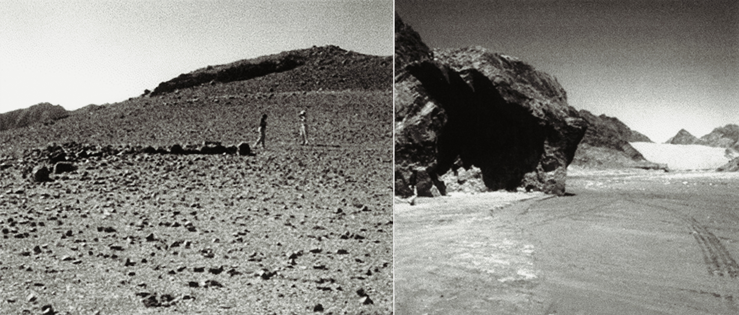
In terms of landscape distribution, the ten sites examined can be split into two groups: the hill type (two small hills: Bu'erhan Shan and Heishimao; and three rolling hills: Gujingou, Siyanjin and Damaidi), and the canyon type (Ge'er'aobao Gou, Molehetu Gou, Dishui Gou, Xifeng Gou, Helankou) (Fig.15). At hill sites, petroglyphs are concentrated at the summit, while in the canyons they are carved on the steep cliff sides. Hill sites all afford remarkable distant views, while those inside the canyons are invariably close to water sources. Notwithstanding these differences, all sites have similar characteristics: difficult access (high in relative altitude), good view, appealing landscape and/or proximity to water (springs, waterfalls, rivers). In some cases, sites of either the hill or canyon type are associated with small shrines (Ge'er'aobao Gou), ovoo cairns, burials (Bu'erhan Shan), or Buddhist inscriptions (Helankou). At the same time, petroglyphs are often carved in positions and ways that allow for distant visibility, and on surfaces that have good sun exposure (possibly to further enhance this visibility). Some sites are also along trade or military routes (Helankou, Daxifeng Gou, and Ge'er'aobao Gou).
These peculiarities and associations indicate that the landscape played a paramount role in the selection of a place in which to carve signs and that in some cases similar choices based on landscape desirability were made also for religious sites. This fact does not automatically make all petroglyph sites into religious sites, but indicates that the two were often intertwined. The Mongols, the last occupants of these areas, considered the entire land (baigal) to be dotted with sacred places which were the focus of ritual and social activities. In fact, even though traditional ‘shamanistic’ healing practices were more often held within the ger (yurt), rites aimed at nature spirits took place on the slopes of mountains, at rivers or lake shores, and near prominent trees (Sauer 2001; Even 1992, 283, 352-80). Interesting is the choice of location for the construction of the traditional ovoo (or obo) cairns, about which the Mongol Mergen Diyanci Lama is reported to have said:
in the erection of an obo, much is said about the erection of the royal obo upon a summit of a high mountain, but in the ordinary run of events, since obos in this land of ours are made as a shrine and receptacle in which dwell the gods and dragons and eight classes of the lords of land and water, . . . then, as to the question of what terrain may be appropriate, one should erect them, praying for blessings and good portents, upon majestic, elevated ground, rich in mountains, water, trees and grass, and such as to make the whole mass of the people fall to their knees when assembled (Charles Bawden 1994, 6-7).
Difficult access, relative height, good views and beautiful landscape in relation to petroglyph sites may, then, indicate a desire to separate the carved signs from the realm of everyday life, placing them on a higher, perhaps spiritual, plane; the sometimes added presence of water could be interpreted as a desire to include life-giving forces in this scheme. When dealing with the material culture of pastoral nomads, however, we should also consider their lifestyle. Shepherds and hunters are excellent climbers, and tend to select high positions with good visibility from which they can tend their herds or spot wild game. This choice comes as no surprise if we consider also the presence of water in the generally dry landscape: this was an additional positive feature, since it allowed both shepherds and animals (to be watered or to be hunted) access to water. In addition, given the importance of distant view and visibility of signs, it is necessary to factor in the proximity of trade or military routes, along which these sites may have worked as significant landmarks indicating the presence of water or other resources. These locations appear then to be desirable places to satisfy both the practical and the spiritual needs of a pastoral and hunting society.
Iconography and Writing
The rock art of the Yinshan and Helanshan consists mainly of engraved signs (petroglyphs, according to current nomenclature) and only minimally of painted images. One painted grotto, Baijigou, Pingluo county, is known from the Helanshan (Li & Sheng 1994).6 The few painted images share the iconography of engravings, even though the paintings are in sheltered spaces (Li & Sheng 1994). The petroglyphs were created by a variety of methods, from grinding to chiselling to incising. The most common method appears to have been chiselling, but there are clear technical differences in production through time, and these seem to go hand-in-hand with stylistic developments. Techno-stylistic analysis suggests that the largest, more sophisticated, and deeper carvings are the oldest and the ones that required most labour (i.e. Helankou faces attributed to the Late Neolithic/Early Bronze Age, Fig. 11; hunting scenes at Gujingou and Damaidi of the Late Bronze Age, Fig. 13a & Fig. 13b - Fig. 14a & Fig. 14b); while the simplest, roughest and most superficial are more recent and less labour-intensive (Siyanjin schematic quadrupeds probably no more than few centuries old, Fig. 12a & Fig. 12b). These may be stylistic traits, though it is possible that early signs carved superficially may have disappeared.
Since the carving activities spread over large part of available surfaces and in some cases the signs were carved with considerable expenditure of time, physical energy, and intellectual effort, a conscious cultural intention on the part of the makers must be assumed.7 The question of why, under what circumstances, and by whom these signs were carved may be difficult to address, but there is enough evidence to draw some conclusions through an analysis of representational themes and the spatial organization of signs.
The motifs include mostly single animals or hunting and shepherding scenes, and to a lesser degree abstract symbols, face/mask motives, hand-or foot-prints, and animal tracks. These three classes of image are represented at all sites, even though there are variations in terms of ratio of representation among the various sites. For example, face/mask motifs seem to be more common and elaborate at canyon type sites; whereas complex scenes are more prominent at hill sites. This may indicate a more privacy-oriented use of canyon sites, perhaps in association with rituals of ancestor worship (given their more secluded positions), versus a more public and open use of hilltop sites for the recording of the common heritage. There is, however, more consistency than diversity in the iconographic themes across the various sites (and a correlation with the petroglyphs of Mongolia and south Siberia), a fact that points towards a certain cultural unity in the area. Variation in motifs relates also to temporal differences and associated stylistic trends.
The representational emphasis on hunting and shepherding which were central to the life, landscape, and subsistence of these peoples indicates that petroglyphs often focused on daily life events or possibly rituals and stories related to these activities. This realization is not meant to imply that rock art was simply a 'portrayal' of life on the steppe or a passive record of myths and legends, but rather that the subjects and objects of hunting and shepherding, in their different forms and styles, were the symbols by which these people defined themselves, and were used to mark, record and communicate (with a human or supernatural viewer) within their cultural framework. The iconography of the face or mask, which is concentrated in certain areas (Helankou, Ge'er'aobao Gou and Molehetu Gou) but has strong connections with the North and Central Asian tradition, may indicate a stronger concern with ritual activities and/or figures associated with worship. These images could portray deities or religious specialists, but are more likely to be representations of the ancestors. Similar images of ancestors are found in the so-called Turkic tomb stones from Mongolia and south Siberia (Bazin 1990, 52-3), and the tradition of ancestor representation is well established in the same areas through the ongghot figures. In addition to the representational images, there are of course numerous abstract symbols. These are more difficult to interpret but, since they recur with a certain regularity at many sites, they may have some connection with clan or group signs.
While land and place had a paramount importance in these symbolic activities the possibility that these pictures functioned also in roles similar to that of writing in literate societies cannot be overlooked. The populations involved were mostly non-literate, and in societies where writing either did not exist or literacy was not widespread, the role of pictures and symbols in communicating and recording ritual or social matters has always been immense (Bahn & Vertut 1997, 203-10). In the later periods, when writing became more widespread among the nomads (after the development in the sixth-seventh centuries of the Turkic alphabet, cf. Bazin 1990), writing and engravings mixed. Eventually petroglyph production disappeared and writing took over the same surfaces. At Helankou, inscriptions in Xixia script appended next to petroglyphs describe them as 'the parents of writing' or 'the writing of the spirits of writing', thus making clear the close connection perceived by literate people between the two sign systems. A similar pattern of integration between writing and images is documented on Easter Island where petroglyphs share the same surfaces with inscriptions in the rongorongo script (Macri 1996).
The visual connection between rock art signs and writing is also readily apparent, particularly in the earliest (pictographic) forms of writing. Although writing is arranged along different logical and spatial concepts, the stylized and shortened manner used to create early pictographs employs many conventions used in rock art.8 Particularly interesting are figures of horned animals. Both in early writing and in rock engravings they are shortened in the body, but have very detailed antlers or horns, the very elements which afford sign recognition (Smith 1998). Similarly, in both media, complex structures (such as houses or charts) are broken down and re-assembled with component parts. For example, at Damaidi a chariot pulled by two horses is depicted with this distorted symbolic perspective: the horses are shown sideways, the chariot box is seen from above, while the wheels are depicted as seen frontally; exactly as we find in ancient Chinese writing (Fig. 14b & c).
The systematic simplification of images, transforming them into easily recognizable symbols, is evidence that the petroglyphs were also used to record and communicate information, perhaps to later generations, neighbouring groups, or even encroaching enemies. The dissemination of such symbols in space makes the wider landscape a sort of pre-modern bulletin board on which every group gets its message (of ownership, friendship, or antagonism), and the ‘owners’ get specific information or instruction. Similar spatial communication systems are documented among several cultures, from Native North America (Mallery (1972 [1893]), to Siberia where the Yukhagirs used signs as a way to convey information about hunting to related wandering groups (Jochelson 1926). Anna-Leena Siikala (1992, 62) has reported that Finnish rock pictures were painted to be representations of killed animals left on hunting paths for communication. This sort of communication is also not unlike that of literate cultures (ancient or modern) which have covered their land with writings: edicts, historical inscriptions or simply ‘graffiti’ marking gang territories. Among them, the Chinese have excelled, and have succeeded in marking crucial spots of their landscape with texts (and associated images) relating to their cultural identity, from historical records to religious texts, and more recently political propaganda. Thus the northern neighbours of the Chinese, far from being uncouth barbarians, were engaged in similar claiming activities even though they used a semiotic system different from fully developed writing. The carving of these images on the landscape could be seen as an effort to inscribe and take possession of the home territory, and thus define the universe of the social group.
In conclusion, it seems feasible, with existing evidence, to consider more than just the religious and ritual aspects in interpreting rock art, and to extend the research to include the role of landscape, territory and the human and socio-political need to leave signs and make records in spatially significant ways. By this means, the religious aspect is incorporated within concerns relating to the landscape, so as to re-create the cultural and political geography of the by-gone makers.
I wish to thank the UCLA Institute of Archaeology for supporting with an Ahmanson Field Research Grant the trip which made this research possible, and the Rhode Island School of Design for a faculty development grant which allowed further research on this topic. This research would not have been possible without the help of many Chinese colleagues: Prof. Gai Shanlin of the Inner Mongolian Institute of Archaeology, Mr Wang Derong of the Ningxia Cultural Relics Bureau. The petroglyph drawings are by Gisel Floretz.
1. The cart (pulled by cattle and with solid wheels) appeared around 3000-3500 bc throughout the Near East, while the horse-drawn chariot appeareds in the eastern steppes by 2000-1500 bc (by 1300 bc the chariot was in Shang China); Di Cosmo (1999, 903); Torday (1997, 10-11). The camel is taken to be evidence of a drying trend in the climate which started probably around 1000 bc.
2. Mounted archery is said to have appeared before 700 BC, even though the stirrups were not used in Mongolia until the fourth century AD; cf. Torday (1997, 11).
3. Such small ceramic pagodas (3-5 cm) have been excavated at the sites of 108 Ta, Baisikou Shuangta, Baisikou Fangta (Li Xiangshi & Zhu Cunshi 1993, 13).
4. The Great Wall is not a single and continuos structure, but a time-layered conglomeration of walls not necessarily linked together. According to historical lore, the Great Walls was first conceived as a continuos defensive line by the First Emperor of Qin in the third century bc by linking the pre-existing state walls of the Late Zhou powers. Later Great Walls, however, did not follow the same line and extended or retreated according to the control on the territory each dynasty was able to afford. Waldron (1990, 1-51).
5. While generally pastoralists, the nomads did engage in limited agriculture, Di Cosmo (1994).
6. In current rock art terminology, engraved signs are called petroglyphs while painted ones are inappropriately termed pictographs. The term pictograph indicates a type of writing and it is used in this article with that meaning.
7. A few signs could be later doodles. Mr Wei Zhong asked some shepherds who sometimes carve images on rocks about the meaning of these signs. The shepherds said there was no meaning, they drew because they were sitting there looking at the pre-existing images and were bored (Wei Zhong pers. comm. 2000).
8. A piece of writing, no matter how primitive, arranges its signs following a sequential logic which may or may not be linguistic; differently, pictorial representation places its signs in accordance to a spatial logic, and hierarchies between signs are established by both their size and position.
Bahn, P.G. & J. Vertut, 1997. Journey through the Ice Age. Berkeley (CA): University of California Press.
Bahn, P.G. & P.A. Helvenston, 2002. Desperately Seeking Trance Plants: Testing the 'Three Stages of Trance' Model. New York (NY): RJ Communications LLC.
Baldick, J., 2000. Animal and Shaman: Ancient Religions of Central Asia. New York (NY): New York University Press.
Ban, L., 1991. Cong yanhua kan beifang minzu xinli jizhi [A look at the northern nationalities mentality from the point of view of rock art]. Nei Menggu Shehui Keixue v 4, 101-7.
Bawden, C.R., 1994. Confronting the Supernatural: Mongolian Traditional Ways and Means. Wiesbaden: Harrassowitz Verlag.
Bayannaoer Editorial Committee, 1987. Bayannaoer zai qianjin. Hohhot: Inner Mongolia People’s Press.
Bazin, L., 1990. Les première inscriptions turques (VIe-Xe siècles) en Mongolie et in Sibérie meridionale. Arts Asiatiques 45, 48-60.
Ben, S. (ed.), 1999. Xin Zhongguo kaogu wushi nian [Fifty Years of Archaeology in New China]. Beijing: Wenwu Press.
Breuil, H., 1952. Four Hundred Years of Cave Art. Montignac: Centre d’études et de documentations préhistoriques.
Bunker, E. et al., 1997. Ancient Bronzes of the Eastern Eurasian Steppes. Washington (DC): A. Sackler Foundation.
Chang, K.C., 1980. Shang Civilization. New Haven (NJ): Yale University Press.
Chen, Z., 1988. Cina: L’arte rupestre preistorica. Milano: Jaca Book.
Chen, Z., 1990. Rock engravings of masks in China. Bollettino del Centro Camuno di Studi Preistorici 25-6, 133-40.
Chen, Z., 1991. Zhongguo Yanhua Faxian Shi [History of the Discovery of Chinese Rock Art]. Shanghai: Renmin.
Chippindale, C. & P. Taçon (eds.), 1998. The Archaeology of Rock Art. Cambridge: Cambridge University Press.
Cultural Relics Editorial Association (eds.), 1981. Zhongguo changcheng yizhi diaocha baogao ji [Collective report on the investigation at the sites of the Great Wall of China]. Wenwu Press.
Devlet, E., 2001. Rock art and the material culture of Siberian and Central Asian Shamanism, in Price (ed.), 43-55.
Di Cosmo, N., 1994. Ancient Inner Asian nomads: their economic base and its significance in Chinese history. Journal of Asian Studies 53/4, 1092-126.
Di Cosmo, N., 1999. The northern frontier, in Loewe & Shaughnessy (eds.), 885-966.
Diószegi, V., 1998. Pre-Islamic shamanism of the Baraba Turks and some ethnogenic connections, in Shamanism: Selected Writings of Vilmos Diószegi, ed. M. Hoppál. Budapest: Akadémiai Kiadó, 228-98.
Eliade, M., 1964. Shamanism: Archaic Techniques of Ecstasy. New York (NY): Bollingen.
Even, M.D., 1992. Chants de chamanes mongols. (Etudes mongoles et sibériennes, Cahier 19-20 1988-1989.) Paris: Labethno.
Fedorova, N., 2001. Shamans, heroes and ancestors in the bronze castings of western Siberia, in Price (ed.), 56-64.
Francfort, H.-P. 1998. Central Asian petroglyphs: Indo-Iranian and Shamanistic interpretation, in Chippindale & Taçon (eds.), 302-18.
Francfort, H.-P. & R.N. Hamayon eds., 2001. The Concept of Shamanism: Uses and Abuses. Budapest: Akadémiai Kiadó.
Gai, S. & S. Lu, 1981a. Yinshan nanlu de Zhao changcheng [The Zhao State Great Wall on the southern Yin Mountains], in Cultural Relics Editorial Association (eds.), 21-4.
Gai, S. & S. Lu, 1981b. Chaoge Qi Chaolukulun Handai shicheng ji qi fujin de changcheng [The Han stone citadel of Choulukulun, Chaoge banner, and the nearby Great Wall], in Cultural Relics Editorial As- sociation (eds.), 25-33.
Gai, S., 1985. Yinshan Yanhua [Petroglyphs in the Yinshan Mountains]. Hohhot: Neimeng Renmin Press.
Gai, S., 1986. Yinshan Yanhua [Petroglyphs in the Yinshan Mountains]. Beijing: Wenwu Press.
Gai, S., 1989. Wulanchabu Yanhua [Petroglyphs in the Wulanchabu Grassland]. Beijing: Wenwu Press.
Grant, C., 1967. Rock Art of the American Indian. New York (NY): Crowell.
Hartley, R. & A.M. Wolley Vawser, 1998. Spatial behaviour and learning in the prehistoric environment of the Colorado River drainage (south-eastern Utah), western North America, in Chippindale & Taçon (eds.), 185-211.
Heissig, W., 1970. The Religions of Mongolia. Berkeley (CA): University of California Press.
Heissig, W., 1992. Schamanen und Geisterbeschwörer in der Östlichen Mongolei. Wiesbaden: Otto Harrassowitz.
Hoppál, M. & A.L. Siikala (eds.), 1992. Studies on Shamanism. (Ethnologica Uralica.) Helsinki & Budapest: Finnish Anthropological Society, Akadémiai Kiadó.
Hoppál, M., 1992. On the origin of shamanism and the Siberian rock art, in Hoppál & Siikala (eds.), 132-49.
Humphrey, C., 1994. Shamanic practices and the state in northern Asia: views from the center and periphery, in Shamanism, History, and the State, eds. C. Thomas. Ann Arbor (MI):
The University of Michigan Press, 191-225.
Humphrey, C. & U. Onon, 1996. Shamans and Elders: Experience, Knowledge and Power among the Daur Mongols. Oxford: Clarendon Press.
Ishjamts, N., 1992. Nomads in eastern Central Asia, in History of Civilizations of Central Asia, vol II, eds. V.M. Masson & A.H. Dani. Paris: Unesco Publishing, 151-69.
Inner Mongolia Cultural Bureau Office of Cultural Relics, 1999. Neimenggu zizhiqu wenwu kaogu wushi nian [Fifty years of archaeology and cultural relics in the Autonomous Region of Inner Mongolia], in Ben (ed.), 83-97.
Jacobson, E. 1988. Beyond the frontier. Early China 13, 201-40.
Jagchid, S., 1989. Peace, War and Trade along the Great Wall. Bloomington (IN): Indiana University Press.
Jochelson, W., 1926 The Yukaghir and the Yukaghirized Tungus. Leiden: E.J. Brill; New York (NY): G.E. Stechert.
Jolly, P., 1996. Symbiotic interaction between Black farmers and south-eastern San. Current Anthropology 37/ 2, 277-304.
Jolly, P., 1998. Modelling change in the contact art of the south-eastern San, southern Africa, in Chippindale & Taçon (eds.), 247-67.
Juliano, A.L. & J.A. Lerner (eds.), 2002. Monks and Merchants: Silk Road Treasures from Northwest China. New York (NY): Asia Society.
Kessler, A.T., 1993. Empires Beyond the Great Wall: the Heritage of Genghis Khan. Los Angeles (CA): Natural History Museum of Los Angeles County.
Klein, C.F., E. Guzmán, E.C. Mandell & M. Stanfield-Mazzi, 2002. The role of shamanism in Mesoamerican art: a reassessment. Current Anthropology 43(3), 383-420.
Layton, R., 1992. Australian Rock Art. Cambridge: Cambridge University Press.
Layton, R., 2000. Shamanism, totemism and rock art. Cambridge Archaeological Journal 10(1), 169-86.
Lewis-Williams, D., 1983. The Rock Art of Southern Africa. Cambridge: Cambridge University Press.
Lewis-Williams, D. & T.A. Dowson, 1988. Signs of all times. Current Anthropology 29(2), 201-45.
Li, X. & Z. Sheng, 1994. Helanshan dongku caihui yanhua. [Painted grottoes of the Helan Mountains], in Ningxia kaogu wenji, eds. X. Cheng et al. (Collected Papers on the Archaeology of Ningxia.) Yinchuan: Ningxia Renmin Press.
Li, X. & C. Zhu, 1993. Helanshan yu Beishan [The Rock Art in Mt Helan and Mt North]. Ningxia Yinchuan: Ningxia Renmin Press.
Lin, S., 1988. Tujue yanjiu [Research on the Tujue]. Taipei: Taiwan Shangwu Press.
Lommel, A., 1967. The World of Early Hunters. London: Evelyn, Adams & Mackay.
Loewe, M. & E. Shaughnessy (eds.), 1999. The Cambridge History of Ancient China: from the Origins of Civilization to 221 BC. Cambridge: Cambridge University Press.
Mallery, G., 1972 [1893]. Picture Writing of the American Indians. New York (NY): Dover.
Macri, M.J., 1996. Rongorongo of Easter Island, in The World’s Writing Systems, eds. P.T. Daniels & W. Bright. Oxford: Oxford University Press.
Martynov, A.I., 1991. The Ancient Art of Northern Asia. Chicago (IL): University of Illinois Press.
Multiple Authors, 1970. A CA book review. Shamanism: the Beginning of Art, by Andreas Lommel. Current Anthropology 11/1, 39-48.
Nelson, S.M. (ed.), 1995. Beyond the Great Wall: the Archaeology of Northeast China. London: Routledge.
Ningxia Cultural Relics Bureau, 1999. Ningxia Huizu zizhiqu wenwu kaogu wushinian chengjiu [Fifty years of archaeology and cultural relics in the Ningxia Hui Autonomous Region], in Ben (ed.), 468-78.
Nordbladh, J., 1979. Images as messages in society. Prolegomena to the study of Scandinavian petroglyphs and semiotics, in New Directions in Scandinavian Archaeology, eds. K. Kristiansen & C. Paludan-Müller. Copenhagen: The National Museum of Denmark, 63-78.
Nowgorodowa, E., 1980. Alte kunst der Mongolei. Leipzig: Seeman Verlag.
Ouzman, S., 1998. Towards a mindscape of landscape, in: Chippindale & Taçon (eds.), 30-41.
Price, N. (ed.), 2001. The Archaeology of Shamanism. London: Routledge.
Rawson, J., 1990. Ancient Chinese and Ordos bronzes. Hong Kong: Oriental Ceramic Society of Hong Kong.
Rozwadowski, A., 2001. Sun gods or shamans? Interpreting the 'solar-headed' petroglyphs of Central Asia, in Price (ed.), 65-86.
Salomon, A., 1998. Ethnography and method in southern African rock art research, in Chippindale & Taçon (eds.), 268-84.
Sauer, C., 2001. The resurgence of tradition in a post-communist society: the role of the Mongolian 'ger'. Central Asiatic Journal 45/1.
Shelach, G., 1999. Leadership Strategies, Economic Activity, and Interregional Interaction. New York (NY): Kluver Academic/Plenum.
Shiji (Historical Records) by Sima Qian, Han, 1972. Beijing: Zhonghua Shuju.
Siikala, A.L., 1992. Finnish rock art, in Hoppál & Siikala, (eds.), 56-67.
Siikala, A.L., 1992b. Siberian and Inner Asian shamanism, in Hoppál & Siikala (eds.), 1-14.
Siikala, A.L., 1992c. Shamanic knowledge and mythical images, in Hoppál & Siikala A(eds.), 87-106.
Smith, B., 1998. The tale of the chameleon and the platypus: limited and likely choices in making pictures, in Chippindale & Taçon (eds.), 212-28.
So, J. & E. Bunker, 1995. Traders and Raiders on China's Northern Frontier. Seattle (WA): University of Washington Press.
Soucek, S., 2000. A History of Inner Asia. Cambridge: Cambridge University Press.
Torday, L., 1997. Mounted Archers: The Beginning of Central Asian History. Durham: Academic Press.
Tuan, Y., 1974. Topophilia. Englewood Cliffs (NJ): Prentice-Hall.
Waldron, A., 1990. The Great Wall of China: From History to Myth. Cambridge: Cambridge University Press.
Whitley, D.S., 1992. Shamanism and rock art in Far Western North America. Cambridge Archaeological Journal 2(1), 89-113.
Whitley, D.S., 1998. Finding rain in the desert, in: Chippindale & Taçon (eds.), 11-29.
Wu, E., 2002. Lun Zhongguo beifang zaoqi youmuren qingtong taishi de qiyuan [On the origin of bronze belt hook of nomads of northern China]. Wenwu 6, 68-77.
Xu, C. & Z. Wei, 1993. Helanshan Yanhua [The Rock Art of the Helan Mountains]. Beijing: Wenwu Press.
Xu, C. et al. (eds.), 1994. Ningxia kaogu wenji. [Collected Papers on the Archaeology of Ningxia]. Yinchuan: Ningxia Renmin Press.
Yu, J. & D. Cheng, 1980. The Great Wall. Beijing: Cultural Relics Publishing House. Zhoushu (Book of Zhou), [Tang] 1971. Beijing: Zhonghua Shuju.
→ Subscribe free to the Bradshaw Foundation YouTube Channel
→ China Rock Art Archive
→ The Rock Art of Huashan, China - UNESCO World Heritage Site
→ Rock Art of China's Helan Mountains
→ Yinchuan World Rock Art Museum
→ Itinerant Creeds
→ Rock Art of Inner Mongolia & Ningxia
→ The Tiger in Chinese Rock Art
→ Life in Rock Art by Chen Zhao Fu
→ In Search of a Vanishing Civilization
→ The Rock Art of Wushan
→ Ancient Rock Carvings from Dazu
→ Bradshaw Foundation
→ Rock Art Network


